
243 Anclote Road
Tarpon Springs, FL 34689
T:727.937.0166
Tf:800.881.1525
|
Marine
Concepts, LLC 243 Anclote Road Tarpon Springs, FL 34689 T:727.937.0166 Tf:800.881.1525 |
||||
 |
||||||
| Sailing
the Wilderness Waterway.
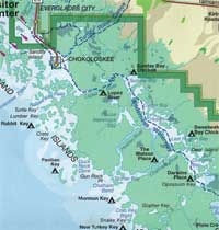
by Stephen Morrill In late December I trailered my Sea Pearl 21 from my home in Tampa down to Everglades City, on the southwest coast of Florida below Naples. "Ev City" is an improbable town, sitting at the mouth of a small river and about six miles of winding channels and mangrove islands from the Gulf of Mexico. Originally the county seat when transportation was all by steamboat in that wilderness, then virtually abandoned when the railroad terminated higher up the coast, the town today subsists on tourists coming to the tiny National Park ranger station and a scattering of die-hard back- country fishermen who still remember the glory days when the stately Rod and Gun Club hosted fishing parties for U.S. Presidents. The Ev. City ranger station is at the northwest corner of the Everglades National Park. While the Park's Homestead entrance near Miami and the Flamingo station at Florida Bay have plenty of facilities for visitors, the station here has one tour boat that putters around the nearest islands, and one pitiful little canoe launch. In the summer things get so slack that people wanting a camping permit find a stack of them under a paperweight in the empty office, and a magic-marker board listing who has already taken what campsite and for what nights. Self-serve; leave notice of who you are, what color your boat is, and who your next of kin are in case you never come back, and leave the form under the paperweight on your way out. And may God have mercy on your soul, because the bugs won't. So I always went in the winter -- through May 1 anyway. And because I used a small canoe I had to fight for the camp sites which you cannot reserve in advance. These sites are usually old homesteads, built on oyster mounds the Calusa indians left, and a full day's paddle apart in a canoe loaded with tent, provisions, and even fresh water. I bought the Sea Pearl specifically for this type of sailing/camping. It holds several times the capacity of my canoe, can go into 90 percent of the same nooks and crannies, and doesn't require backbreaking labor to get there. There being no boat ramp at the park, I drove across the causeway from Ev. City to Chokoloskee Island, a sort of suburb to Nowhere and the site where, in 1910, local citizens gunned down a bully named Ed Watson in one of the more colorful episodes of an already colorful frontier. I would be sailing into Watson's old territory, now part of the Park. From what I had read of him in "Killing Mr. Watson" by Peter Matthieson, I was happy I wouldn't be tangling with him. I set up the boat and launched it at about eleven a.m. and was soon taking long lazy tacks southeast across Chokoloskee Bay towards the Lopez River. In a canoe, the campsite half way up Lopez River was usually a half-day trip and a good place to stay overnight if you had started late. But in the Sea Pearl I felt ambitious. Besides the wind was out of the southeast and likely to remain so for several days and if I had to beat against that I wanted to do it in the open Gulf where I had more sea-room. In less than two miles I came to the turnoff into Rabbit Key Pass and started out toward the Gulf, on a broad reach, boards up. This was what I bought this boat for, skidding around corners, drifting across the shallows, the mangroves all around and only my own skill in balancing tidal currents and wind to keep me moving and only my map-reading, water-reading, even tree-reading skills to keep me from getting lost. I'll probably buy a GPS one of these days but frankly, I hardly use a compass in the western `glades mangrove forest, where there are so many twists and turns that your overall heading is no clue as to where you should be going. I soon emerged into the Gulf, skimming past Rabbit Key a few hundred yards distant. After shooting Ed Watson, angry residents of Chokoloskee had towed his body out here behind a boat and buried it on the beach. When the sheriff arrived several days later they dug Watson up and put him into a coffin that is buried today in Fort Myers. The coroner dug some thirty- plus bullets out of Watson, and didn't even count all the buckshot but they allowed as how Watson leaked pretty bad. Nobody, incidentally, seemed to know exactly WHO shot thirty or more different calibers and types of bullets into Watson and no one was ever prosecuted. Perhaps he shot himself with an entire armory and then swam out to Rabbit Key. I tacked out into the Gulf in a light breeze and sighted Pavilion Key, where I planned to stop for the night. The breeze dwindled as I made my way southeast, the mangrove shoreline to my left, the flat Gulf to my right. I spotted a canoe even farther out than I was and dropped off the wind to move out to meet it. I found a couple paddling south toward Flamingo, 99 miles from Ev. City down the Wilderness Waterway. They had decided to try the offshore route so long as the Gulf stayed flat. They of course wanted to look the Sea Pearl over and admired the idea of a sailboat that could go "gunkholing" into the everglades. When our chat ended, they paddled off toward Pavilion Key and I sat there. The wind had died entirely. It's just the shift-over from land breeze to sea breeze, I told myself. An hour later I was still telling myself this but I was starting to disbelieve it. I got out the oars and started rowing. Pavilion Key was about two miles off and after a half-hour or so a nice squall appeared. I laid the oars on the deck and gratefully sailed into the squall. This is great, I said. Too much wind and I can't see a thing for all the rain, but at least I'm making progress so long as I stay on this southeast tack. When the squall blew away I was facing northwest and headed full-tilt back toward Ev. City. I'd forgotten that inside squalls, the wind "clocks" completely around. Maybe I could use that compass after all. I got out the oars, cheered by the knowledge that I had farther to row now than before the squall. I crawled into Pavilion Key about sunset. Pavilion Key is really a large lagoon surrounded by a half-dozen islands, but the whole still fairly open. The name dates to the time in the early 1800s when a pirate poisoned a female captive and left her to die on this island, under a palm-thatch lean-to he had built for shelter. Caught a few miles away by the U.S. Navy he protested that he had built the woman a "pavilion" for her death-bower and was due leniency for his display of thoughtfulness. The navy promptly hanged him. What they did with the woman's body, I don't know. A half-dozen canoes were drawn up on the beach and dome tents had popped up like multi-colored mushrooms. I stopped in briefly to visit with my new-found friends and to use the toilet, then rowed away and anchored behind Dog Key in what I felt was a strategic locale, open to the wind but protected from the seas by an oyster bar. You're not required to sign in at the ranger station if you don't plan to use the camp sites. No squabbling over the few slots (Pavilion Key is one of the few large sites in the park). This tent-on-a-boat concept is great too because you can avoid most bugs by anchoring away from shore and also because your tent automatically aims itself into the wind, so that you always get the breeze through the front screen. The wind that night gusted to about 30 knots but the Sea Pearl rode this out pretty well and the 15-pound Bruce anchor worked fine. The wind was still about 15 out of the southeast when I got underway at 8 the next morning. Today all I needed to do was to get to the mouth of Lostman's River, farther down the coast. Off I went, the inward tacks led into calm waters and I would sail in until I would see bottom. The outward tacks were into increasingly choppy water. I usually time my tacks because otherwise I have a tendency to give up too soon. I soon passed Storter Bay, the outlet for both the Huston River and the Chatham River. Watson's sugar-cane farm was up the latter, and is today a park service campsite, still decorated with odd bits of machinery and the foundations of Watson's house. I continued south, paying very close attention to landmarks--of which there are precious few here--because it's a lot harder to see these things from offshore in a relatively fast- moving sailboat than up close and personal in a canoe. I reached Lostman's River about four and snaked my way in through an oyster-bar-studded entrance. One of the old residents had built a cabin on the bank at the entrance and the park service had once used it as a ranger station. But the rangers complained about the lonely duty and today the station is abandoned, only a short radio tower still in use and that only to relay a tidal-gauge signal from farther up the river. I had planned to anchor behind the island that spans the mouth of the bay here. This is where Ed Watson murdered a young couple because they would not get off his property--or not quick enough. Property rights were subject to debate in those days. Watson was a stickler for his legal rights which seemed to include the right to kill anyone who disagreed with him or even wanted a paycheck for a month spent in Watson's island cane fields. His retirement policy was a bullet in the head and some scrap iron tied to your feet. He was so sloppy about the latter that at least four bodies bobbed up to be recovered by passing locals. But I had an hour before sunset and you can make good progress in an hour if the wind is right. I sailed in past the entrance and up the river, mostly on a reach or broad reach. Up here the water was fresher from all the rain we have had this winter and some alligators had ventured into the usually-salty estuary. The wind stayed good and I kept going, all the way inland to Onion Key Bay and right across it into a small bay with a narrow entrance and one tiny island in the center. Perfect. One alligator cruised back and forth across the entrance like an armored gunboat. I anchored almost dead-center in the bay, slightly closer to the upwind side, paying attention to getting a long downwind span clear of any trees. Mosquitoes don't hunt you by sight, but by smell, and especially exhaled carbon dioxide. So the farther they have to fly against the breeze to reach you the less likely they are to make it. Nevertheless, shortly after sunset the first few mosquitos arrived, panting from their long trip and looking very thirsty. I put up the tent and retired therein, using the rowing seat as a table to eat on and read a book on. The light, of course, also attracted mosquitos and soon I had a few more inquisitive snouts poked in through the mesh. But the even worse plague--the tiny flies we call "no-see-ums"- -couldn't make it against the wind at all. In the morning I ate breakfast with gusto. Today was payback time. The wind was still from the south and today I would be going back, and going back through the inner bays and islands, a downhill run all the way. Off I went, downwind, boards up, sometimes rudder up too. Onion Key Bay, then through the narrow pass into Two Island Bay (apparently so named because it's one of the few bays that has NO islands in it). At Lostman's Five Bay I pulled up at the campsite there to use the porta-potty. This campsite was no more than a wet bog about 20 feet square. In drier times it might be better but I doubt it. I was afraid to explore much into the trees because I knew that once off the sunlit dock and landing, about ten gazillion mosquitos were wondering about lunch. I cannot tell you how good it was to have my own portable campsite and not have to rely on these pitiful protrusions above the high-tide line. This place would be a misery at night. In fact the ground was so wet I'd probably have slept on the dock. Of course the dock was rotting away too, board by board. One of the less-obvious instincts boaters develop is to walk down old wood docks on the nail-lines, so your weight is over the stringers underneath. I forgot for one incautious instant. When I left there was one less board than when I had arrived. In the next small creek I heard a familiar thumping, as if a Trinidad steel drum band was approaching. Then voices, one of which--a woman's-- exclaimed "Hey-a sailboat!" In here!." They could see my sails above the trees, I guess. Around the corner came a party, several aluminum canoes powered by people who think you need to end every stroke with a bang on the side of the boat for luck. We all stopped to chat a moment. They were two couples on their way to Flamingo, with two days behind them and six to eight before them. They liked the Sea Pearl but one of the men opined that paddling was better. I didn't say that I had thought the same thing for ten years or more and only recently had wised up. But his companion turned to him and said, "We have six more days to go in this thing? You're nuts." I decided to move on before things got more noisy. I had, in times past, stayed at my next stop, just through the narrow creek into Plate Creek Bay. There the park service had built a chickee, a wooden platform and dock standing in the water. I stopped only to try my skill at coming up to the dock without dropping sail. I prefer chickees because they are usually less buggy and of course, there is no sand to get into everything. A side benefit of Hurricane Andrew in 1991 was all-new chickees. Andrew blew all the old ones away toward Mexico. All the old, commercial-built, porta-potties fetched up somewhere in the mangroves too and the new ones, which are specially built for the park service. No smell, ample toilet paper, room to dress or change clothes, and self-composting. The old ones needed emptying and one of the more odious and odorous ranger jobs was "honey-bucket patrol" in a big Boston Whaler with a tank and a pump. I moved on to what I knew would be my first real challenge of the day. Plate Creek is narrow. In a canoe it's wonderful. In a Sea Pearl, it's too much of a good thing. Or too little. I sailed in, lost the wind, and soon thought it wise to furl the sails lest I tear them on the tree branches. I rowed but soon it became too narrow for the oars. I used a canoe paddle where I could, a long bamboo pole where I could use that, and did a lot of hauling myself along by tree branches. All this was greatly hindered by the fact that I still had the masts up and was too dumb to get them down. Finally I got hung with a tree limb between the two masts and so far as I could see, not enough room to swing either bow to stern enough to clear the rear mast. I was getting hot and frustrated and on top of everything, the tide was running against me. I eyed the offending branch. It didn't look all that sturdy and it was just out of my reach. What the heck, I asked myself. What else could possibly go wrong? I jumped for the branch, got a good grip on it, and sure enough it broke off and came down. I felt a great pain in one of my fingers which also seemed to be attached to the branch. I know--you fishermen out there are all chuckling, you little booby- trappers. Sure enough, there was a fishhook wrapped around the branch all these years and now the fishhook was stuck in ME. Now there is a school of thought about this. Push the hook on through, they say, rather than trying to back it out against the barb. Yeah, right. I yanked that sucker out. I couldn't recall the last time I'd had a tetanus shot so the more blood the better. As soon as I had the finger under control I took down the masts and continued my pushme-pullyou trip through Plate Creek. This of course only leads to Dads Bay and then Alligator Bay and the latter only leads to Alligator Creek--narrower and longer than Plate Creek. But now I had the system--such as it was--down. I also made a vow to get a motor of some sort for situations like this. I've since invested in a 52-pound-thrust electric. Ahhh. Out of Alligator Creek and into Tarpon Bay I put up the masts for good, spread the Sea Pearl's wings and away we went. It was a real sleighride. Around the corner and into Cannon Bay. Out of Cannon Bay through a maze of small islands and past Opossum Key, another camp site and the former home of an insane French ornithologist named Jean Chevelier. Chevelier died one day when Ed Watson came up the Chatham River to discuss property rights with him. Watson claimed Chevelier had died of old age right before his eyes but others said looking at Watson tended to age a man fast. Beyond Opossum Key I entered Chevelier Bay and the Sea Pearl actually lifted onto a plane for a moment, skimming across the surface like a racing daysailer. A powerboat came out of the islands behind me and gradually overtook me at about the halfway point, where I nipped around a dogleg, lost the wind for a moment, then picked up again. The wind was strengthening for sure. The boat had a father-son team, and was the first powerboat I had seen back here all day, though so long as you follow the intracoastal markers--which I was doing--you normally see boats every hour or so. Chatham River drains both Chevalier Bay and Last Huston Bay and as I crossed from one bay to the other the wind whipped up the reach of the river and threatened to bowl me over. But I had anticipated that and just luffed as needed for the few minutes I was exposed. By now it was mid-afternoon and as I skimmed across Last Huston Bay and Huston Bay I looked at the chart. Where to camp overnight? I decided on a spot in Oyster Bay. Oyster Bay flew past and I decided, no, I'd camp in Sunday Bay. Sunday Bay came and went and I sailed off on a tangent into Cross Bays and missed the exit into Lopez River--the first time I had missed a turn in three days. Now this is rather ironic: Around 1971 I was the first "tourist" to use the Cross Bays-Hurddles Creek passage through from Lopez River to the Turner River. The rangers took me to the city hall to borrow a photocopy machine and they gave me a copy of a hand-drawn map for that stretch and told me to look for the pieces of cloth they had tied to branches along the way. I recall rowing a small rowboat as far as I could row, then laying on my back and pulling myself along by the overarching mangroves just inches above the gunwales. Today, thanks to lots of boat traffic and tidal surge, the channel is wide enough for anyone. Well, I thought, I'll sail down the Lopez River and camp near the mouth, in Chokoloskee Bay. Off I went, now having to tack and do so across a mud "bar" that runs lengthwise up the center of the river. The sun was setting and the wind dying too. After an hour or more of this annoying short- tacking--then board up for the bar--then board down--then repeat, I reached the mouth of Lopez River. The sun set and the wind gave out entirely and I unshipped the oars. This is where I had decided to camp but now a strange passion overcame me. I saw a vision and the vision was of an Arby's mocha shake. And there was an Arby's at exit 23 on Interstate-75. I rowed around some islands and in the distance could see the rooftops of the homes on Chokoloskee Island. It got dark and still and I kept rowing, sucked onward by that mocha shake. Finally, at about eight at night I rowed up to the boat ramp. A gaggle of tourists poured out of a neighboring trailer park and helped me with lights, lines and plenty of advice. They had seen me rowing across the bay and wanted to know all about this sailboat that could sail in the mud. I treated myself to a sponge-bath in the trailer park's restroom and put on the clean clothes and dry shoes I had left in my car. Smart me. And off I went, heading for Tampa by way of Exit 23 and that Arby's mocha shake. Marine Concepts , 243 Anclote Road , Tarpon Springs, FL 34689 , 800.881.1525 |
||||||
 |
||||||